
The short answer as to whether there is a fracking threat to the Forest of Dean is a YES, and will be until we get licences removed which allow a company to explore for gas until December 2020. To get the licence, the company has pledged to drill at least one gas well.
We are sharing all our investigations so far regarding the potential of unconventional exploration and recovery of hydrocarbons (oil and gas), including the technique of fracking (hydraulic fracturing of rock) in the Forest of Dean.
A company which has no apparent website, South Western Energy, was in December 2015 formally granted two Petroleum Exploration & Development Licences (PEDLs) to explore for hydrocarbons/ petroleum/ gas and oil in the Forest of Dean and Wye Valley, including the SW corner of Herefordshire, and also the Sharpness area across the Severn.

The Government’s “potential impact” zone (the red square above – while the green shaded areas are the licencing area) borders Newent, Wooton-under-Edge and Chepstow and includes the whole of Ross-on-Wye, Berkeley (including its nuclear waste storage facility) and Monmouth, stretching to a few miles west of Gloucester.
Here are more detailed maps (provided by the Government when the licences were subject to ‘consultation’) of the licenced blocks.
These two western blocks, subject to one of the two PEDLs, might be judged at being at less risk to fracking as the licensee has made no commitment to drilling here (but that does not mean the licensee won’t, so the threat is still there):

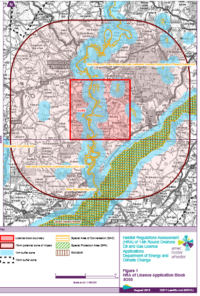
Note: the blue buffer zones marked on the maps are only protected from surface level works and not from fracking underneath them
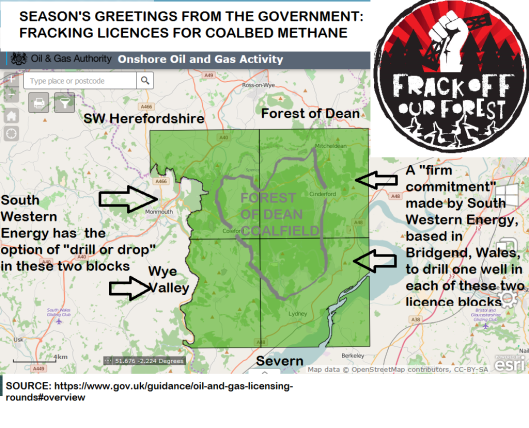
And here are the three blocks (or two, with one split into two sections) where South Western Energy has made a “firm commitment” to drill at least one well somewhere within the three:


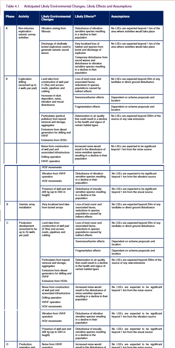
Each block is marked with ‘potential impact’ zones by the Government. This refers to its Habitats Regulations Assessment, which concerns the impact to protected wildlife species (and no other impacts), tabled as follows:
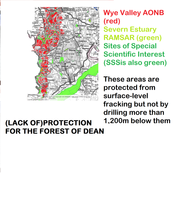
The Government passed a ‘statutory instrument’ (secondary legislation) in November 2015 to allow “associated hydraulic fracturing” to take place at a minimum level of 1,200m below Areas of Outstanding Natural Beauty, Sites of Special Scientific Interest and EU-protected nature sites, as well as Groundwater Protection Zones as shown locally below:

But here’s the catch… these flimsy protections only apply to “associated hydraulic fracturing”, legally defined (see below) as when a minimum of 10,000 cubic metres (or 1,000 cu m per stage) of fluid is used. Typically, if fracking occurs in the coalbed, it only uses 200 cubic metres per fracking stage, so it would be legally possible for fracking using less fluid to take place at no minimum depth.
Section 50, clause 4b of the Infrastructure Act 2015 states:
4B Section 4A: supplementary provision
(1)“Associated hydraulic fracturing” means hydraulic fracturing of shale or strata encased in shale which—
(a)is carried out in connection with the use of the relevant well to search or bore for or get petroleum, and
(b)involves, or is expected to involve, the injection of—
(i)more than 1,000 cubic metres of fluid at each stage, or expected stage, of the hydraulic fracturing, or
(ii)more than 10,000 cubic metres of fluid in total.
Unless we succeed in getting the PEDLs/ licences withdrawn, we have this threat (of Stages A and B, as explained above) hanging over us until December 2020, when the PEDLs’ exploratory phase expires. We are committed to ensuring the oil and gas industry does not even get its foot in the door.
And it’s not just us here – In December, South Western Energy were also given PEDLs to explore for Coalbed Methane and Shale Gas in Somerset, Wiltshire and Dorset. People in South Wales are currently fighting battles, winning some of them, against the same fracker under different company names. 10 wells have already been drilled, another 15 are being resisted. (The companies were granted PEDLs in a previous licensing round).
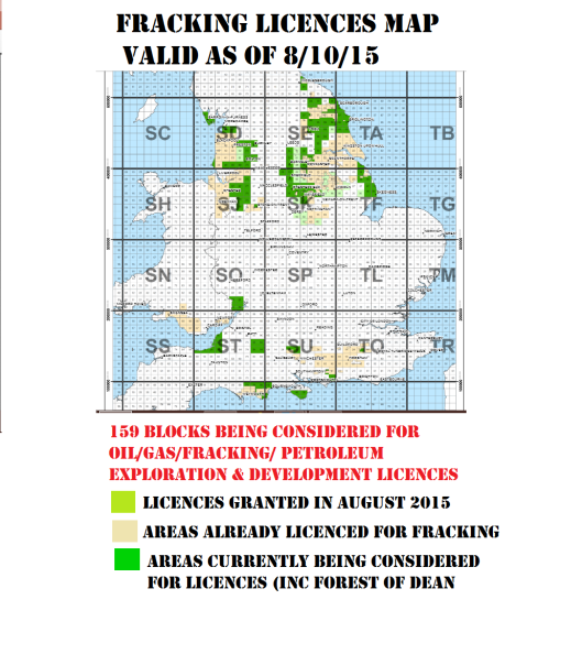
Since this map was produced, every block being considered for licences was granted licences, a total of 159 across England. The exploration stage of the licences granted in the last round (the 13th Landward Round) expires at the end of June 2016. Then the licencee, if they have done what they said they would do in their Work Programme have the option of another five years of evaluation, followed by the option of taking on a 20-year-long licence to develop gas or oil.
For more information on what fracking is, see xxxxxxx [FORTHCOMING PAGE – LINK TO FOLLOW]
For the threats fracking poses locally, see xxxx [FORTHCOMING PAGE – LINK TO FOLLOW]
For more on the company that wants to frack, see xxxx [FORTHCOMING PAGE – LINK TO FOLLOW]
For more on the bigger picture and the need for solidarity with other areas fighting fracking, see xxxxx [FORTHCOMING PAGE – LINK TO FOLLOW]
As we anti-frackers are opposed to any form of extreme or unconventional oil and gas/ petroleum extraction, beyond this restrictive legal definition of ‘associated hydraulic fracturing’ we use the term ‘fracking’ as shorthand for all these technologies – including Coal Bed Methane/ Coal Seam Gas, Shale Gas and Underground Coal Gasification/ Syngas.
To be granted licences/ PEDLs, South Western Energy was required to submit a ‘work programme’ to the Government’s Oil & Gas Authority (OGA). Government guidelines for licence applicants say:

The licence applications have not been made public, but examples can be seen from PEDLs granted in previous application rounds, eg:

(The above “work programme” applies to SW Energy’s “sister” company Coastal Oil and Gas Ltd and its “partner” as regards this licence, which expires on June 30, 2016, and has just given up on one site in Llanharan in Mid Glamorgan within this PEDL)
Government guidelines to operators (‘landward’/ onshore oil and gas explorers and developers) state: “A Firm Drilling Commitment is a commitment to the Secretary of State to drill a well. It is only appropriate if the Applicant is certain that s/he would drill if awarded a licence. Essentially drilling could begin immediately, subject only to outside factors like other Regulatory regimes, rig availability, or weather. The well should therefore be drilled early within the Initial Term [the initial term lasts five years].”
“A Drill-or-Drop ‘Commitment’ leaves the decision whether or not to drill entirely with the licensee. If a well is to be drilled, it should be planned to complete drilling within the Initial Term.”
The licences holder’s stated primary objective in the Forest of Dean area is to explore for Coalbed Methane (CBM). But there is nothing stopping the explorer from looking for shale gas as well, or investigating the potential of Underground Coal Gasification (UCG).
South Western Energy will almost certainly say: “We’re not going to frack.” That may well be the case – another, bigger company would most likely move in to develop a gas field, potentially using fracking techniques. South Western Energy will begin softly-softly, drilling small boreholes to take rock samples, taking the samples at various levels (they say between 600-1200m, but there are no depth restrictions) to a laboratory to be baked to ascertain their potential for producing gas and oil. The later stage of exploration would include more invasive operations, differing depending on whether testing the feasibility for CBM, shale or UCG is the end object.
It will cost South Western Energy less than £10,000 per year to pay for its two licences for the five-year window of exploration (based on the fee of £25 per square km)… the amount will double successively for a company developing gas or oil production (which could start as late as 2030 and go on for 20 years)… See below:

WHAT THE GOVERNMENT HAS TOLD US
Frack Off Our Forest supporter Baroness Jan Royall of Blaisdon managed to arrange a meeting with the energy minister Lord Bourne of Aberystwyth in February 2016, at the House of Lords, following questions being asked in the Lords on January 25.
Here three of the four of us that went down are pictured with Jan Royall (on the right) shortly before our meeting, on the riverside terrace of the Houses of Parliament:

We presented Lord Bourne and officials from the Oil & Gas Authority and Department of Energy and Climate Change (DECC) with this document. Lord Bourne and officials gave us more than 30 minutes of their time, and appeared to listen properly to us. More meetings were proposed, but to date (2/4/16) we have heard nothing more.
This is what we had confirmed/ were told:
- One gas exploration site would be the size of two football pitches
- The site could be on Public Forest land or private land
- The Deputy Gaveller, based at the Forestry Commission in Bank House, Coleford, is responsible for granting permits on behalf of the Coal Authority, providing the site is within the coalfield and Hundred of St Briavels.
- South Western Energy wants to begin by drilling a stratigraphic well, to test rocks between 600m and 1200m down. This would be a narrow borehole from which core rock samples can be taken, and tested for gas suitability in a laboratory.
- The Government’s Senior Geoscientist, Toni Harvey OBE (she received her honour for ‘services to the UK energy industry’ and worked for oil/gas giant Amoco for 20 years in Colorado before working for the UK’s energy department from 1999), told us she was satisfied South Western Energy was financially competent, and could meet all the costs of exploration and cleaning up afterwards.
(Guidelines state: “There are no specific financial criteria for operators other than those applied by the OGA to operators in their capacity as licensee. Financial viability and capacity checks are made for any new licensee. The OGA must be confident that any company is likely to continue in sound financial health for the foreseeable future, and the company must demonstrate that it has access to sufficient funds to pay for its share of all the elements of the proposed Work Programme (whether those elements are Firm or “Drill-or-Drop” commitments).”)
WHAT GEOLOGISTS, LOCAL MINING EXPERTS AND RESEARCH HAVE TOLD US
- There is no methane in the Forest of Dean coalfield. There is not a single known instance of a miner encountering methane underground, and miners have historically used naked flames, carbide lamps and pit ponies in the pits.
- The coalfield is a maximum 450m below the surface, according to the deepest level of mining at the former Princess Royal colliery, Bream. There are 17 seams, most of them very thin. However, a report produced by a CBM prospector Onshore English Gas Ltd for a licence application in 1997 (search for SO60 in pre-licence applications here) reckoned the coal measures reached a maximum depth of 630m.
- Explorers have looked for oil and gas in the past in the Forest of Dean and we gather none has been found. In 1963, a licence was granted jointly to three petroleum prospectors covering the same or similar range in the Forest of Dean with London offices, Continental Oil Services Limited, Marathon Petroleum (G.B.) Limited and Envoy Oil Limited. There is no record of any work been done or gas or oil found. In 1997, Onshore English Gas (OEG) applied for the same map grid areas under licence now, in the 8th Onshore Round. Its stated objective was coalbed methane. We can find no record of OEG being granted a licence. Below is some of its licence application – is South Western Energy looking to do what OEG apparently didn’t do?

- Most of the coal seams have been worked, but there are pockets of unworked coal ‘pillars’ and a stretch between Lightmoor and Mallards Pike (including the Awres Glow valley) which have not been worked because they have proved inaccessible using surface and deep-mining methods.
- Some gales are owned by the Coal Authority, many others by freeminers.
- Freeminers can sell their gales to anyone for any purpose. Gales have been sold since the 19th century, then nationalised in the 1940s, and some remain privately owned by non-freeminers.
- Over the centuries there have been hundreds, if not thousands, of mining operations, many unrecorded and uncharted.
- The Forest of Dean coalfield is very wet – one of the main reasons deep mining finished in the 1960s. One retired mines surveyor asserts that there is a vast underground lagoon under the centre of the Forest where water pressure has connected the extensive deep mine workings. He says it would be impossible to drain the coalfield, as shown by the volume of water which drains predominantly north to south from the coalfield at Norchard, near Lydney.
- In 1999, it was hypothesised by scientists (see pages 23-33) that water from the Forest of Dean found its way to the reservoir which feed the Bath hot springs. The predominant theory is that the water for the UNESCO World Heritage site (confirmed as protected from fracking by two Government ministers) comes from the limestone karst (caves etc) system in the nearby Mendips. However, the study argues for a much wider catchment area, theorising that water could find its way from the Blaisdon/Longhope/May Hill areas through the Malvern Fault System (including through Old Red Sandstone, and the faults themselves), which runs underneath the bed of the Severn, and also percolating through the limestone which continues from Wigpool to beyond Chepstow and passes underneath the Severn, beneath the Severn Bridge.
- Mark Harper said the British Geological Survey confirmed to him there was no shale gas under the Forest of Dean. My own conversations with BGS staff is that there is no evidence of shale gas, and it’s unlikely there is any… but not inconceivable. As for CBM, the BGS have reported there is no or little potential here, nor for UGC as the coal seams are so close to the surface.
OPPOSITION TO FRACKING IN THE FOREST OF DEAN
POLITICIANS
From the start of our campaign, we have had councillors supporting us, and parties and groups from across the political party spectrum.
West Dean Parish Council was the first to unanimously declare itself against fracking, calling an extraordinary meeting in Berry Hill in September 2015 to determine its position.
Others we know of who have now declared their opposition are Coleford Town Council, Cinderford Town Council, Mitcheldean, Awre, Ruardean, St Briavels and Soudley & Ruspidge Parish Councils. (Apologies if we missed any council out, please let us know if we have.)
In October 2015, Forest of Dean District Council unanimously agreed a statement which expressed opposition to fracking “at this time”. We have been informed the wording used was the result of cross-party consultation and designed to avoid any accusation of prejudice in future planning applications.
We understand the council’s Fracking Task Group, set up as per the motion, met for the first time recently, but we have yet to hear what was decided at that meeting.
Shortly after this historic district-wide vote, Councillor Gethyn Davies broke ranks and declared he supported fracking in a letter to a newspaper (despite voting against it!). Coun Davies’s ward Tidenham is outside the licencing zone (but within the potential impact zone). Councillor Brian Robinson (also a county councillor who abstained from the vote there), of Mitcheldean ward, told BBC West’s Politics Show “we have yet to be persuaded…” and later told a county council Environment and Communities Scrutiny Meeting that he disagreed with sending a letter on behalf of the county council calling for licences to be withdrawn (despite voting to do so with Forest of Dean District Council) because regulatory agencies would prevent it from happening:
“I’m from the Forest of Dean, where the district council has already expressed a view. My concern is for the safety of the Forest of Dean, and I found the session this morning very interesting… Because it was clear that there are quite a lot of regulations, particularly from the Environment Agency and the Health and Safety Executive that would prevent these activities taking place, where they would cause damage to groundwater and surface water or any materials used in the process escaping into the natural environment.
That said, I take on board a lot of what Councillor Graham Morgan said earlier and from that you would actually probably conclude that the prospect of fracking or methane extraction from coalbed industry in the Forest is almost zero, because the opportunity just doesn’t exist.
But the opportunity not existing isn’t a certainty and I think what I would want to happen is for the certainty that we as a council have the right to determine the Minerals and Local Plan issues, so that a local decision on whether they can proceed could be made, and I’d like to ensure that the Environment Agency also undertook their duties and promptly, and both of those would actually prevent fracking in the Forest.
But in order to achieve that, we have to make sure we take control of planning activities. I therefore believe that today the best thing we could do is not to do anything that would undermine the ability of this council to determine the planning decision and I will therefore not be supporting the motion. [FOOF: Read our leaflet, please!] [CHAIRMAN: Be quiet!]
It will undermine our ability to actually prevent fracking from taking place in the Forest, which is manifestly an unsuitable location. But we have to do that using the tools available to us, which are planning authority rules and are Environment Agency rules and they I believe will be… [sufficient? Last word inaudible]”
Councillor Robinson did attend a public information evening after this organised by Mitcheldean Parish Councillors, the WI and others, and having watched Frack Free Somerset’s 2014 Marco Jackson film The Truth Behind The Dash For Gas commented that perhaps the Environment Agency might not be safely relied upon to protect the environment from fracking.
For more on the saga with Gloucestershire County Council, see this page about what we’ve achieved so far [LINK TO FOLLOW] but suffice to say that 21 councillors eventually in February 2016 voted unanimously to declare opposition to fracking and to write a letter to the Government calling for licences to be withdrawn – 26 councillors abstained, so the vote was carried. (Strangely, although The Citizen was present at the meeting, nothing was reported in the paper – surely nothing to do with the editor being betrothed to the Leader of the county council, who had called for all councillors to abstain from the vote?)
We have not seen the letter due to be sent to the Government, but presume/ hope it has been.
We have also been given a statement unequivocally opposing fracking here and elsewhere in Europe by South-West Member of the European Parliament Molly Scott-Cato:
“The forest of Dean is a unique and special landscape which must be protected against the environmental destruction that fracking threatens. I stand with the local Councils in the area who have expressed their dismay and opposition to fracking in the Forest of Dean and Sharpness area. Communities across the region don’t want the noise, air, light and water pollution that this industry would bring. In a recent vote in the European Parliament I voted for no new fracking to be authorised anywhere in EU member states. I am delighted that there is cross-party opposition to fracking in the Forest of Dean. For the sake of our climate we must leave fossil fuels in the ground, the South West is not for shale”
We are awaiting a statement from our other MEP, Clare Moody.
Jan Royall (Baroness of Blaisdon) is, as previously mentioned, a champion for us in the Lords, and we have also had support from the Bishop of St Albans, plus Labour, Lib Dem and Conservative Lords. Read or view the debate in the Lords.
As for the three MPs whose constituencies include the licence zones – Mark Harper (Forest of Dean), Jesse Norman (Hereford and South Herefordshire) and Neil Carmichael (Stroud) – all have voted with the Government on fracking.
PEOPLE POWER!
 While many of our political representatives are on board (bar the House of Commons), and helping us in council chambers, in Parliament, and by writing letters and attending events, we need confirmation from the public as a whole that the majority oppose fracking.
So we teamed up with the Toxin Free Network people, following a successful strategy used in Australia and in Cheshire and Sussex here – social surveys in a bid to declare communities Gasfield Free, to send out a clear message that the Government and company has No Social Licence to explore here.
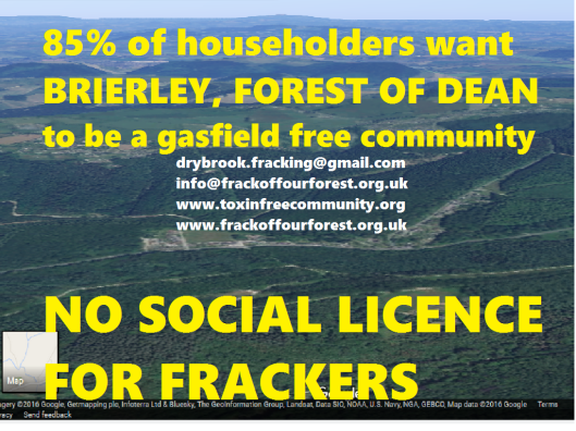
Two separate teams have been engaged in neighbourhood surveys (for more on how to get involved in this, see this page [LINK TO FOLLOW]. The Drybrook team, after delivering to all the approx 100 houses in Brierley a DVD and information sheet, and then visiting each household, were able to declare the first community result in the Forest of Dean: 85% of households in Brierley want to live in a gasfield-free community, 7.5% are unsure, while 7.5% said yes to gas exploration.
The Drybrook team is currently meeting once a week on Wednesday evenings to work their way through the much bigger community of Lydbrook.
Meanwhile, a separate ‘South Forest’ team has very nearly finished surveying Parkend (approx 250 homes), and we await the result. Indications are that the majority also want to live in a gasfield-free community.
Supporters Fran Challice and Coleford Town Councillor Kevin Ball launched a petition in Coleford where people can declare their objection to shale gas, CBM and ‘syn gas’ manufactured from Underground Coal Gasification and collected 570 signatures all from people living within the boundaries of the area’s Neighbourhood Development Plan (NDP). This will be fed into the Coleford NDP.
We decided to extend the petition to throughout the licenced areas (apologies, we haven’t got round to going to the Sharpness area yet), and it can now be signed in more than 60 outlets (in addition to the places named below, it’s also in Ruardean Woodside’s shop). We hope that the signatures and names can be adopted for various purposes, including fed into other NDPs. The petition is also a chance to raise awareness and have conversations about the fracking threat to the Forest of Dean.

Ultimately, if all diplomatic powers of persuasion through our campaigning fail, direct action methods such as blockading and camping will be required. Text this number to join the rapid responders (and also if you have any intel – bear in mind that elsewhere in the UK, infrastructure has been moved on to sites before they go through planning): 07902 129695.

FRACKING LOCATIONS, TIMETABLE AND ACTIVITIES: WE CAN ONLY SPECULATE…
Given that the Government has not made public the submitted ‘Work Programme’ of the licensee South Western Energy, but only told us the first thing they propose to do is to drill a stratigraphic well and indicated the size of a gas well exploration site (the following stage), and that South Western Energy have so far proved impossible to communicate with, let alone revealed their intentions or plans, we can only take theories and rumours we’ve heard forward…
There are a number of hypotheses we are looking into, put forward by various Frack Off Our Forest supporters and from our own research. We’d say it’s well worth everyone keeping an eye out for activity such as ground clearance and preparation, track improving etc in the following sites, but keep your eyes peeled throughout the licencing zone.
IS IT SHALE THEY’RE LOOKING FOR?
Although South Western Energy has stated CBM as the “primary prospectivity” type in the application, the Government says “a PEDL licence covers any hydrocarbon and is not limited to this classification”.
For shales (the most common form of rock found) to contain gas or oil, depends on many factors. The first is that the rock was formed at least partially from organic matter, ie from fossilised plants and animals. Though this is not the case everywhere, in the Forest of Dean, the various sandstones found were often laid down in deserts and barren conditions. The limestones, however, were formed in shallow seas, and contain varying amounts of organic matter, or carbons.
For more detail on the local geology, see this newly created geological Timeline
The rocks need to be ‘mature’ enough to have formed gas or oil within their pores. This means they need to be ‘buried’ under sufficient thicknesses of rock to have maintained the heat required for petroleum. Rock can also be ‘over-mature’, meaning its temperature has caused any gas/oil to have evaporated.
Oil or gas-producing shales tend to be found within folds, of which there are a great many in the Forest of Dean. Natural fractures increase the porosity of the shale. Some geologists argue that the severity of local folding of rocks, which took place between 330 and 220 million years ago, mean the layers are so cracked any methane or gas/oil would have escaped.
There are two types of limestone rock which outcrop within the licencing area… that they outcrop means there is a good chance they continue underneath other layers of up-folded rock: Silurian shales and Carboniferous limestones. There may also be Ordovician and Cambrian shales beneath the Silurian layers.
If the Government information is still current: that South Western Energy wants to explore at between 600 and 1200m down, this leads us on to two hypotheses – both of which involve shale gas and neither coalbed methane (unless they genuinely believe that, contrary to all available knowledge, the coalbed extends deeper).
Plenty of borehole data exists in the Forest of Dean, as boreholes have been sunk and drilled since the 19th century by mining prospectors. However the deepest only goes down 300m. Deeper boreholes exist at Fownhope in Herefordshire, in the Usk valley (or Inlier) in Monmouthshire, and to the west of the Malverns and evidence of Cambrian shales from the oldest rock outcrops – Tortworth, near Dursley and the Malvern Hills themselves. These four points surround the Forest of Dean and geological connections can be made: the Malvern fault system which borders the Forest at May Hill/ Longhope/ Huntley, between Newnham and Blakeney and carries on south to the Keynsham area (the Malverns and Tortworth sit on it). The ridges which form the eastern border between the Malvern Line and the Forest of Dean coalfield culminate around the Woolhope Dome, including at Fownhope, while the Usk Inlier is the gap between and outer limit of this geological micro-terrane which comprises the Forest of Dean, Wye Valley and Monmouthshire hills/sloping plateau and the next much larger one, the South Wales coalfield.
A recent BGS document on UK Shale Gas prospects compares “satellite basins of the Worcester Graben”, with the Barnett Shale of the Fort Worth Basin in north-eastern Texas and south-western Oklahoma, a major fracking centre for the past 10 years. The areas referred to are between Berkshire and Somerset, between the Worcester Graben (which includes Huntley, Newent, Gloucester, Tewkesbury, Cheltenham) and the Variscides (which include the Mendips and Quantocks, as well as the Forest of Dean).
There are three target era rocks for shale gas exploration:
The youngest, Jurassic, occurs in a thick layer in David Cameron’s Oxfordshire constituency of Witney. It’s strange, then, given that the law – the Infrastructure Act 2015 – makes it a “legal objective” for the “economic recovery” of onshore petroleum, that Witney escaped licensing (PEDLs). In the home county of Surrey, similar Kimmeridge Clays are currently being hyped by the oil industry following successful oil flow tests at Horse Hill.
The middle-age rock, Mississippian Carboniferous – said to have the most potential for shale gas (this includes the Millstone Grits of northern England) blankets and underlies most of South Wales, the Forest of Dean, Bristol Channel, and Somerset and beyond to southern Ireland and Pennsylvania, once a tropical shallow sea called the Euroamerican Seaway. They act like a broken misshaped bowl which contains the coal measures, all around the Forest of Dean. (Puzzlewood and Clearwell Caves, as well as Symonds Yat Rock and Devils Chapel are examples of the dramatic scenery produced at the western rim of the coalfield). As well as around, they are thought to lie beneath most of the coalfield. The only known exception is in the Yorkley/ Viney Hill/ Lydney area, where there is no layer of limestone between that the old red sandstones which underlie the whole area.

The presumed extent of Carboniferous Limestone (turquoise for outcrops, blue for underlying other sedimentary rock layers), laid down when the area (in blue and turquoise) was part of the Euroamerican Seaway circa 350-320 million years ago. The licenced areas for fracking are roughly marked as well as wells drilled, ready to be drilled (have planning consent), and wells proposed. Water from these rocks (aquifers) could find its way into the reservoir that feeds the UNESCO World Heritage Site of the Bath hot springs – it has been confirmed by two Government ministers that fracking will not happen within the vicinity of the springs, but the catchment area may include the Forest of Dean (according to a 1999 scientific report, pages 23 to 33).

The oldest type of target rock, Pre-Carboniferous Black Shales are probably more than 3km down in the central part of the Forest of Dean, increasing the risk of them being over-baked so far underground. However, they outcrop and fold between the summit of May Hill and Longhope. There are tiny outcrops of Silurian Much Wenlock limestones in an intermittent line including Hope and Flaxley woods and Popes Hill. Immediately across the Severn from Purton (near Blakeney) even older shales outcrop. The Fownhope and Fowlet boreholes to the south-west of the Malverns have shale gas potential, says the report.
Silurian limestones were created between 450 and 400 million years ago when most of Wales was under the sea, and May Hill was near the coast
SCENARIO 1: exploration in the central Forest

Geological map of the Central Forest of Dean. To the right of the red line, no carboniferous limestone is thought to lie beneath the coalfield (while to the left of it, it does) The bright orange, turquoise, green, blue, and grey bands represent limestones, the browns and pinks Devonian sandstones. Below, a cross-section view from west to east…

As stated further above, the information supplied to us by the Government when we met officials at the House of Lords is that the target range for South Western Energy is between 600m and 1200m. The deepest extent of the coalfield, which is Trenchard sandstone (from 300 million years ago), is not believed to extend as far down as 600m. The carboniferous limestone layers beneath the coalfield (from 350-330 million years ago) probably extend at least 150m further, before reaching non-organic layers of Devonian sandstone, believed to be between 1000 and 2500m thick.

Could a preferred site be the Awres Glow valley between Mallards Pike and Lightmoor? Coal cannot be got out here by surface, adit or deep mining as seams are so close to the surface and on the flat. In the 1990s, a big scheme was proposed, including new access roads from near the Dilke, which would have led to a 2-mile-long stretch of public forest land being an opencast mine site. Some of those who successfully fought against opencast then are raising fears this site – the coal underneath, the gale, is we understand privately owned by a man from Wales who isn’t a freeminer. The area isn’t the most scenic in the Forest partly because, we understand, the Forestry Commission clear-felled the area in preparation for the failed opencast operation. Now there exists a large patch of unwooded valley, probably about the right size for an exploratory drilling site. Also, Lightmoor is on the list of proposed district council sites for development (“employment generating uses”).
The Awres Glow valley is on the border of the Staple Edge monocline (geological structure), which was named as being most prospective for coalbed methane in a 1997 pre-licence application (along with the Clanna Anticline, which runs from Tidenham to Bream).
It has also been claimed by a man who allegedly witnessed it (according to a 1990s newspaper article) that mustard gas canisters were buried shortly after WW2 in a line parallel with Awres Glow valley, just to the west of it. We know the Dean was used as a store/ dumping ground for wartime munitions. Only recently ordnance was found near Ruspidge, and the area had to be evacuated while it was safely detonated. Coupled with ancient and new flytipping and dumping of dead animals down mine workings and iron-ore scowles – of which there are many known incidents down the centuries. There are many hazards associated with drilling down in the centre of the Forest of Dean.

We have heard other rumours/ speculation that the sites could be near Parkend, some fields near the Orepool, Sling or on the proposed Cinderford Northern Quarter development (where at the time of writing, £14.75m has been spent but the college, housing or industrial buildings have not materialised, or been conclusively confirmed), or the strip of land that was recently violently cleared of its farmer-occupiers on Yorkley Court Farm (a dress rehearsal for clearing a future anti-fracking Community Protection Camp?). The Coal Authority map reveals there are two licenced areas for future activities (marked ‘underground’) in Awres Glow and Oakenhill, near Whitecroft, and one for opencast (also in Oakenhill wood, between Parkend and Whitecroft).
The Deputy Gaveller, Dan Howells, based at the Forestry Commission’s Bank House in Coleford, is in charge of allocating gales in the Hundred of St Briavels (which includes almost the entire coalfield) on behalf of the Coal Authority. We have not spoken to the DG ourselves (we’ve been informed the only way we can meet with local Forestry Commission officials is if their higher-ups, Defra, permit and/or organise the meeting, hardly a means for a frank exchange of views). But we understand the Government’s interpretation of the Dean Forest Mines Acts is that its considered ok to drill through other people’s gales as long as no coal is removed. A freeminer we have spoken to disagrees with this.
CONCLUSION: The object could be shale gas from carboniferous limestones if the exploration site is in the central Forest of Dean area.
SCENARIO 2: exploration to the east of the Forest, and across the Severn.

 East of the carboniferous limestone ridge – from Mitcheldean and Longhope south to Blakeney and Etloe, Silurian mudstones cover most of the surface, with bands of limestones and possibly shale-gas-bearing mudstones which accumulated in marine conditions more than 400 million years ago, when May Hill was close to the coast (further east) and a deep sea covered mid Wales. Older strata of rocks outcrop across the Severn near Tites Point and down to Tortworth, near Dursley.
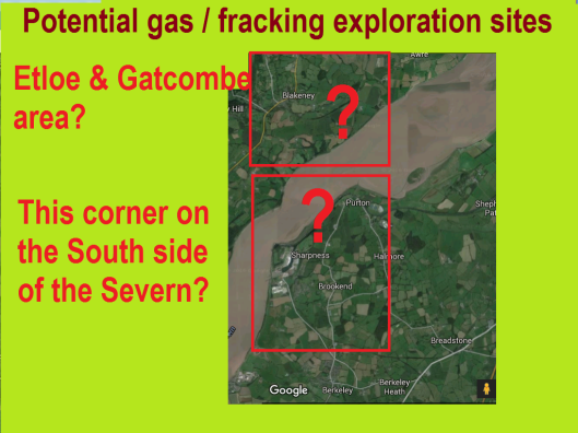
CONCLUSION: If the exploration site is to the east or south east side of the Forest of Dean, the object could be gas or oil from Silurian or older shales (420-550 million years old).
SCENARIO 3: exploration in the area of the former deep coal mines (Bream, Cannop, Brierley, Drybrook, Cinderford, Ruspidge)

The final possibility really doesn’t bear thinking about – but this is still mooted for central Scotland, Swansea Bay and the Loughor Estuary (between the Gower and Carmarthenshire). Underground Coal Gasification could be a ‘final solution’ applied in the deep-mined areas between Ruspidge and Drybrook, including Brierley, or Bream or Cannop. This would involve pumping out all the water from the flooded mine workings and causing the dregs of the coal to combust (ie burn) by pumping oxygen or another solution into the worked seams. The vapour would then need to be collected and processed to make syn gas, probably at a power station on site. The numerous breaches of environmental laws have led to UCG operations being permanently shut down in Australia and one town in the US has been abandoned as it continues to burn as a result of UCG operations decades later.
CONCLUSION: They wouldn’t… or would they try UCG?

Graphic explaining Underground Coal Gasification
THE QUEST TO MEET SOUTH WESTERN ENERGY
We understand from a “police public liaison officer” that he (the Police Constable) has spoken to “the geologist” (presumably Oliver Taylor) about South Western Energy’s plans – the police officer made the phone call, he said. Gloucestershire Police have mooted us campaigners having a meeting with South Western Energy to discuss their plans. This was initially meant to have taken place at police HQ in Bamfurlong, near Cheltenham, in February. Then it was going to be at the end of March. We have still heard nothing. (Mind you, we are suspicious of police claims of ‘impartiality’ with good reason). The Government minister Lord Bourne also told us he would seek a meeting between us and SW Energy.
While we assume the police meeting would be more about intelligence gathering (for a policing/ corporate advantage) than us being able to try and make the case to those wanting to trash our beautiful Forest, we would dearly like to hear what the company wants to do. We suspect it will begin with the line “we’re not going to frack”. Yes, SW Energy may not intend to do any actual fracking, but the exploration paves the way for another, bigger company to frack (or similar)!
So, unless we succeed in getting the licences withdrawn (which has been our goal since they were granted), SW Energy is licenced until December 2020 to explore this area (and others) for oil and gas. The exploration work itself will probably take between one and two years, so there’s every chance the company is currently biding its time, trying to attract investment and waiting for the market to pick up, and we won’t see any planning applications in until 2017 or 2018. Playing the long game suits SW Energy as they’ll hope that our campaign has died down and perhaps more and more of the power-brokers in the Forest of Dean can be bought off by then.
Until then, South Wales – where the licences expire at the end of June – is the focus of frackers Gerwyn Williams and Oliver Taylor of SW Energy and a plethora of other tinpot gas explorer companies.
Frack Free Wales is involved in a six-week Energise Wales Camp on the A48 between Cardiff and Cowbridge, the heart of Gerwyn country. Why not go along and join our fellow fractivists and show solidarity?
TO FRACK OR NOT TO FRACK?
Just to reiterate an important point made earlier, the Government has restricted “associated hydraulic fracturing” to a minimum depth of 1000m, or 1200m below Groundwater Protection Zones, European-protected environmental sites (including bat habitats), Sites of Special Scientific Interests and Areas of Outstanding Natural Beauty. If you consider the 200m extra distance underground a restriction it means the western licence blocks, plus pockets of the rest are “protected”.
However, a closer look at the legal definition of “fracking” applicable in these restrictions reveals it only refers to “high-volume” fracking, where a total of 10,000 cubic metres of fluid is used per operation. Any amount less than this escapes the legal definition.
CBM exploration or production sometimes does not involve any fracking, or stimulation of the coal using this method, and when it does as coal isn’t as hard or as far down as shales, it typically only uses one-fifth of the fluid (water, chemicals and sand). This it can legally do with no minimum level legally proscribed (guidelines indicate anywhere from 100m down is fair game).
The current shale oil operation at Horse Hill, Surrey is at just over 800m, and the company insists there is no need to frack as oil is flowing freely. However, campaigners believe the company will use fracking at a lesser volume than meets the legal definition once the flow has stopped, and/or will go further down than 1000m and use high-volume fracking. Given the environmental issues and health concerns already reported here, whether fracking as legally defined is employed or not, there is every reason to oppose this onshore petroleum extraction.
The latest (successful) application for a well to test rock strata (from Gerwyn Williams’s UK Methane company), at Pontrhydyfen in the Afan Valley east of Neath – the subject of a new film A River, narrated by Michael Sheen with a Massive Attack soundtrack – aims to examine various layers for both coalbed methane and shale gas potential. Gerwyn Williams said: “It is an exploration borehole. It is nothing to do with production and it is nothing to do with fracking.” (But it is potentially the first stage towards both).
Whatever they say on the licence application and whatever assurances locals may give that there is no methane in the coalfield – shale gas exploration can take place. If no gas-bearing rocks are found in one place, the exploration can make more holes in the ground elsewhere.
These stratigraphic wells may be hard to object to on planning grounds, as they are only little holes and cause little disruption in themselves. Whatever decision our authorities would end up making, it’ll be up to us to ensure South Western Energy don’t get their foot in the door in the first place.
But it could be the case that the frackers can just move in without any planning consent.
In January, the BBC and other media outlets reported the Government will “no longer need planning permission to drill boreholes to monitor water quality and carry out seismic monitoring”. The plan to change the law was revealed in December 2015, but we don’t think the statutory instrument required has been introduced yet.
So we may need to stay vigilant and keep campaigning for another few years… or the ‘phoney war’ (comparable to the first year of the Second World War) may be over tomorrow. I do hope everyone stays on board and stays the course, however long and drawn-out it might be.
WILL THE GOVERNMENT GIVE THE GREEN LIGHT, REGARDLESS OF WHAT PLANNERS DECIDE?
The Infrastructure Act together with a Statutory Instrument gives a minister – Greg Clark, Communities Secretary – the power to overrule any local democratic decision, independent of any planning inspectorate’s ruling on an appeal. So all eyes are on what happens over Lancashire, where a planning appeals inquiry has just taken place with Lancashire County Council and people vs Cuadrilla and the Chamber of Commerce. In this case, the planning inspector will make recommendations to Greg Clark and he will make the final decision (no one’s sure when that’ll be).
ARE WE NEEDLESSLY WORRYING?
Some people continue to be of the opinion there will be no fracking here. Mark Harper, Forest of Dean MP and now Government Chief Whip, said during his pre-election hustings in early 2015 he was confident there was no shale gas beneath the Forest of Dean and so – even though Gloucestershire was included in areas offered up to potential frackers from 2014 – there would be no fracking. When potential licences were announced in August 2015, the MP said perhaps they could be for Coal Bed Methane (CBM). Mr Harper replied to many letters specifically referring to Shale Gas fracking, endorsing the Government’s support for it (he is in the Government of course, and his job is to get Conservative MPs to vote for Government proposals).
Even after two Petroleum Exploration and Development Licences (PEDLs) were confirmed for four/five blocks in the Forest of Dean and Sharpness areas, with the operator – South Western Energy – committing to drilling at least one exploratory well in one of the eastern blocks – Gloucestershire County Councillors, including Labour, Lib Dem and Conservative, briefed media and meetings that they believed fracking was unlikely to take place. The Leader of the council, Mark Hawthorne, told the full council this in February, but declined to elaborate.
From what we can discern here are the various reasons cited by the ‘you’re worrying about nothing’ people, followed by our counter arguments. Of course, it’s not a case of ‘us’ and ‘them’, it’s just many people understandably like to avoid over-concern and unnecessary stress and conflict.
We sincerely hope we can overcome these worries, but that’s not possible until licences to explore for petroleum/oil/gas/hydrocarbons here in the Forest of Dean are completely withdrawn.
This is why, until the licences are removed, we feel our concern/ worry is justified:
-
ENVIRONMENTAL PROTECTION
THEY SAY: The Governmental regulatory agencies and planning controls will ensure fracking/ exploration doesn’t happen here, as it will be deemed too environmentally risky.
WE SAY: A leaked letter and memo to George Osborne from the secretaries of state for the environment, energy and communities state a commitment for speeding up the procedure in getting fracking going, with agencies such as the Health & Safety Executive and Environment Agency charged with making the case FOR in planning applications. To date, the EA has not refused a permit for any CBM exploration, and the EA didn’t even bother issuing permits until 2013. The process of getting a permit rarely, if ever, requires a site visit before or during operations. (During our meeting with Lord Bourne and Government officials in February 2016 he instructed officials to ensure the EA makes site visits in this area). The threat of the cost of fighting an appeal, and also for punitive measures by Government, plus the loss of financial incentives, has been seen to have influenced councillors’ decisions to grant planning consent in other councils, notably in South Wales. Another thing to bear in mind is that of mission creep. The earliest stages of exploration (seismic testing, borehole drilling) are nowhere near as environmentally damaging as the later stages (which these less invasive early stages pave the way for). Here’s the guidelines the Government has produced explaining the permits needed etc for shale gas fracking… -
NO ECONOMIC SENSE
THEY SAY: The bottom’s fallen out of the global gas and oil industry, thanks to the Saudis/ the US fracking industry, shares are plummeting and South Western Energy’s latest accounts (from December 2014) show they are almost £9,000 in the red.
WE SAY: It’s true that the oil/gas industry is at a low, but there’s no guarantee it won’t bounce back. The main raison d’etre for fracking in the UK and Europe is to create and stimulate new markets for investors. At the moment, many investors don’t seem to be biting, but the situation is always subject to change. Some investors see fossil fuels as ‘stranded assets’ – some think there’s no point going after them at all, but others maintain that in a few years their value will increase due to scarcity and rarity. Hedge funds etc may think it’s worth investing now while the price is low. Our investigations into South Western Energy and its owner-director Gerwyn Williams indicate he has £400,000 in available capital, but the Government claims to be content his company is financially secure. -
THERE’S NO GAS
THEY SAY: Anyone who has been underground knows there is no methane in the coalfield, and any company would be wasting a fortune bothering to explore. (Let them waste their money and resources exploring, nothing will come of it.)
WE SAY: 1. The actual process of exploring for Coal Bed Methane, following a first stage of seismic surveys, boreholes for water and rock monitoring, will involve a space the size of two football pitches being cleared of all vegetation, the draining of a colossal amount of water which contains radioactive substances, and will involve many truck movements, possibly new roads, as well as noise and light pollution from 24/7 drilling activities. 2. Even if a sample borehole convinces SW Energy there is no point in searching for coalbed methane, their licence permits exploration for shale gas deeper down in various levels of limestone rock. Their data may also help them or another company to apply for an Underground Coal Gasification (UCG) licence from the Coal Authority – methane is not required for this technology, which involves setting fire to worked coal seams and converting the vapour into synthetic gas (or syngas).
-
WHAT’S THE PROBLEM WITH FRACKING ANYWAY?
THEY SAY: If we have a natural reserve which can help keep the lights on, we should allow it to be exploited just as the Forest has provided timber, iron, stone and coal. It can be done safely (unlike in America and Australia).
WE SAY: There are more than 500 studies and reports worldwide which show harm caused by fracking and fracking could be behind a 30% rise in methane emissions in the US. An argument made in favour of fracking in that it is better for the environment than coal has been increasingly countered recently. The Government has also shot itself in the foot not only by economically, politically and legally disabling the renewable energy industries, but also cancelling a £1bn programme to develop carbon capture and storage, which might have been used by the fracking industry as a means of justification, a claim that greenhouse gases could be contained out of harm’s way. In this country, at existing operations at Horse Hill in Surrey and in Cheshire, unknown substance discharged into ditches, neighbours’ complaints about nosebleeds and headaches, drill parts held on with gaffer tape have all been recorded on film, in photographs and news reports, casting doubt that in Britain there will be a “gold standard” enforced in the industry. However, energy minister Andrea Leadsom insists people shouldn’t believe the scaremongering about fracking.
FOR MORE ON THIS, SEE THE ‘WHAT IS FRACKING’ PAGE… [LINK TO FOLLOW]

Reblogged this on Wessex Solidarity.
LikeLike
nice one 🙂
LikeLike
Thank you for this comprehensive information 🙂
LikeLike
Reblogged this on thereadphonebox.
LikeLike
Thanks owen I will be updating Monmouth transition at their meeting tonight (5/4)
LikeLike
Reblogged this on VeryVexed and commented:
Thank you Owen
LikeLike
I now have a whole new understanding of the Forest’s ancient infrastructure, thank you Owen.
‘F’ is for forest NOT fracking!
LikeLike
very comprehensive report – thanks! Even more resolved to ensure it won’t happen here.
LikeLike
Pingback: FRACKING LICENCES NOW FULLY GRANTED FOR THE FOREST OF DEAN – Owen Adams: An advocate for the Forest of Dean